Indus River
| Indus | |
|---|---|
| Sindh, Sindhu, Hindu, Abasin, Sengge Chu, Yìndù | |
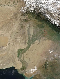
Satellite image of the Indus River basin.
| |
| Countries | China, India, Pakistan |
| Length | 3,200 km (2,000 miles) approx. |
| Watershed | 1,165,000 km² (450,000 miles²) approx. |
| Discharge | Arabian Sea |
| - average | 6,600 meters³/sec. (230,000 feet³/sec.) approx. |
| Source | Confluence of the Sengge and Gar rivers |
| - location | Tibetan Plateau, Tibet, China |
| Mouth | Sapta Sindhu |
| - location | Sindh, Pakistan |
| - elevation | 0 meters (0 feet) |
The Indus River (Urdu: سندھ Sindh; Sindhi: سنڌو Sindh; Sanskrit and Hindi: सिन्धु Sindhu; Persian: Hinduحندو ; Pashto: Abasin ّآباسن"Father of Rivers"; Tibetan: Sengge Chu "Lion River"; Chinese: 印度 Yìndù; Greek: Ινδός Indos) is the longest and most important river in Pakistan and one of the most important rivers on the Indian subcontinent. The name "India" is a reference to the Indus River. Originating in the Tibetan plateau in the vicinity of Lake Mansarovar, the river runs a 3200 kilometer (2000 mile) course, through Ladakh district in Kashmir and Northern Areas, flowing through the North in a southerly direction along the entire length of country, and merges into the Arabian Sea near Pakistan's port city Karachi. The river's estimated annual flow stands at around 207 cubic kilometers. Originating with water from snow and melting glaciers, the river supports an ecosystem of temperate forests, plains and arid countryside.
The major cities of the Indus Valley Civilization (IVC), Harappa and Mohenjo Daro, dating to around 3300 B.C.E., represent some of the largest human habitations of the ancient world. Most scholars believe that settlements of Gandhara grave culture of the early Indo-Aryans flourished in Gandhara from 1700 to 600 B.C.E.. The Indus was crossed by the retreating armies of Alexander the Great, and by the Muslim armies of Muhammad bin Qasim, Mahmud of Ghazni and Babur, who crossed the river to strike into the inner regions of Gujarat, Punjab and Rajputana. The Indus plains were also under the domination of the Persian Empire and the Kushan Empire. The Indus River provides vital water resources for the economy of Pakistan, especially for the breadbasket of Punjab province, which accounts for most of the nation's agricultural production, and Sindh. Access to the waters of the Indus has been a subject of contention between India and Pakistan, who signed the Indus Waters Treaty in 1960.
Overview
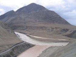
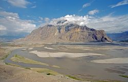
The ultimate source of the Indus is on the Tibetan plateau in the vicinity of Lake Mansarovar; it begins at the confluence of the Sengge and Gar rivers that drain the Nganglong Kangri and Gangdise Shan mountain ranges. The Indus then flows northwest through Ladakh-Baltistan into Gilgit, just south of the Karakoram range. The Shyok, Shigar and Gilgit streams carry glacial waters into the main river. It gradually bends to the south, coming out of the hills between Peshawar and Rawalpindi. The Indus passes gigantic gorges 4500 - 5200 meters (15,000-17,000 feet) high near the Nanga Parbat massif. It swiftly flows across Hazara, and is dammed at the Tarbela Reservoir. The Kabul River joins it near Attock. The remainder of its route to the sea is in plains of the Punjab and Sind, where the river becomes slow-flowing and highly braided. It is joined by Panjnad River at Mithankot. Beyond this confluence, the river, at one time, was named the Satnad River (sat = seven, nadi = river) as the river was now carrying the waters of Kabul River, Indus River and the five Punjab rivers. Passing by Jamshoro, it ends in a large delta to the east of Thatta, near Pakistan's port city, Karachi. The total length of the river is 3200 kilometers (2000 miles). The river has a total drainage area exceeding 1,165,000 square kilometers (450,000 square miles). Its estimated annual flow stands at around 207 cubic kilometers. Beginning at the heights of the world with glaciers, the river feeds the ecosystem of temperate forests, plains and arid countryside. Together with the rivers Chenab, Ravi, Sutlej, Jhelum, Beas and the extinct Sarasvati River, the Indus forms the Sapta Sindhu ("Seven Rivers") delta in the Sindh province of Pakistan. It has 20 major tributaries.
The Indus is one of the few rivers in the world that exhibits a tidal bore. The Indus system is largely fed by the snows and glaciers of the Karakoram, Hindu Kush and Himalayan ranges of Tibet, Kashmir and Northern Areas of Pakistan. The flow of the river is also determined by the seasons; it diminishes greatly in the winter, while flooding its banks in the monsoon months from July to September. There is also evidence of a steady shift in the course of the river since prehistoric times; it has deviated westwards from flowing into the Rann of Kutch.
The Indus provides the key water resources for the economy of Pakistan, especially the breadbasket of Punjab province, which accounts for most of the nation's agricultural production, and Sindh. It also supports many heavy industries and provides the main supply of potable water in Pakistan.
History
Paleolithic sites have been discovered in Pothohar, with the stone tools of the Soan Culture. In ancient Gandhara, evidence of cave dwellers dating to 15,000 years ago has been discovered at Mardan.
The major cities of the Indus Valley Civilization (IVC), Harappa and Mohenjo Daro, date back to around 3300 B.C.E., and represent some of the largest human habitations of the ancient world. The Indus Valley Civilization extended from Balochistan to Gujarat, with an upward reach from east of River Jhelum to Rupar on the upper Sutlej. The coast settlements extended from Sutkagan Dor at Iranian border to Lothal in Gujarat. There is an Indus site on the Oxus river at Shortughai in northern Afghanistan, [1] and the Indus site Alamgirpur at the Hindon river is located only twenty-eight kilometers from Delhi.[2] To date, over 1,052 cities and settlements have been found, mainly in the general region of the Ghaggar-Hakra River and its tributaries. Among the settlements were the major urban centers of Harappa and Mohenjo-Daro, as well as Lothal, Dholavira, Ganeriwala, and Rakhigarhi. Only 90 to 96 of the over 800 known Indus Valley sites have been discovered on the Indus and its tributaries. In Harappan times, the Sutlej, now a tributary of the Indus, flowed into the Ghaggar-Hakra River, in the watershed of which were more Harappan sites than along the Indus.[2]
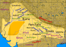
Most scholars believe that settlements of Gandhara grave culture of the early Indo-Aryans flourished in Gandhara from 1700 to 600 B.C.E., when Mohenjo Daro and Harappa had already been abandoned. The name Indus is a Latinization of Hindu, in turn the Iranian variant of Sindhu, the name given to the Indus in the Rigveda. Sanskrit sindhu generically means "river, stream," probably from a root sidh "to keep off"; sindhu is attested 176 times in the Rigveda, 95 times in the plural, more often used in the generic meaning. Already in the Rigveda, notably in the later hymns, the meaning of the word was narrowed to refer to the Indus River in particular, for example in the list of rivers of the Nadistuti sukta. This resulted in the anomaly of a river with masculine gender; all other Rigvedic rivers are female, not only grammatically, but in the way they are referred to as goddesses and compared to cows and mares yielding milk and butter.
The Indus has formed a natural boundary between the Indian hinterland and its frontier with Afghanistan and Iran. It was crossed by the armies of Alexander the Great, when the Greek forces retreated along the southern course of the river at the end of the Indian campaign. The Indus plains were also under the domination of the Persian Empire and the Kushan Empire. The Muslim armies of Muhammad bin Qasim, Mahmud of Ghazni and Babur also crossed the river to strike into the inner regions of Gujarat, Punjab and Rajputana.
The word "India" is a reference to the Indus River.
Geography
Tributaries
|
|
|
Geology
The Indus River feeds the Indus submarine fan located in the Arabian Sea, which is the second largest sediment body on the Earth at around 5 million cubic kilometers of material eroded from the mountains. Studies of the sediments in the modern river indicate that the Karakoram Mountains in northern Pakistan are the single most important source of material, with the next largest contribution from the Himalaya, mostly via the large rivers of the Punjab (the Ravi, Jhellum, Chenab and the Sutlej). Analysis of sediments from the Arabian Sea by marine geologists Peter Clift and Jerzy Blusztajn has demonstrated that prior to five million years ago the Indus was not connected to these Punjab Rivers, which instead flowed east into the Ganges. Earlier work, also by Peter Clift, showed that sand and silt from western Tibet was reaching the Arabian Sea as early as 45 million years ago, implying the existence of an ancient Indus River by that time. The delta of this proto-Indus river has subsequently been found in the Katawaz Basin, on the Afghan-Pakistan border. Most recently the Indus was paralleled by the ancient Saraswati River, which the Rigveda suggests flowed from the Himalaya between the Sutlej and the Yamuna Rivers, close to modern day Chandigarh. Archaeological hydrological radio carbon datings indicate that the Saraswati river was totally dry by 1900 B.C.E..
Climate
The Indus delta is one of the driest in the Indian subcontinent, lying just to the west of the Thar Desert of Rajasthan. Rainfall is unusually erratic owing to the passage of cyclones from the Arabian Sea. The Punjab plains, however, receive considerable rainfall from the summer monsoon: at Abbottabad the average annual rainfall is around 1,200 millimeters (47 in.) and at Murree around 1,700 millimeters (67 in.) with as much as 730 millimeters (28 in.) in July and August alone. The upper basin of the Indus receives 10 - 20 millimeters (4-8 in.) of rainfall (higher in the west) in the winter months owing to northwestern winds. Higher elevations in Kashmir and the Northern Areas receive a large amount of precipitation in the form of snow, but the lower valleys are extremely dry and quite warm in the summer. Annual temperatures fall below freezing in the northern mountainous regions in the winter, while exceeding 38 °C (100 °F) in the plains of Punjab and Sindh in the summer. Jacobabad, which is one of the hottest spots in the world, lies to the west of the river in Sindh.
Wildlife
Accounts of the Indus valley from the times of Alexander the Great's campaign indicate a healthy forest cover in the region, which has now considerably receded. The Mughal Emperor Babur writes of encountering rhinoceroses along its bank in his memoirs, the BaberNameh. Extensive deforestation and human interference in the ecology of the Shivalik Hills has led to a marked deterioration in vegetation and growing conditions. The Indus Valley regions are arid with poor vegetation. Agriculture is sustained largely due to irrigation.
The blind Indus River dolphin (Platanista gangetica minor) is a sub-species of dolphin found only in the Indus River. It formerly also occurred in the tributaries of the Indus river. Palla fish (Hilsa ilisha) of the river is a delicacy for people living along the river. The population of fish in the river is moderate, with Sukkur, Thatta and Kotri, all in the lower Sindh, as the major fishing centers. Dams and irrigation have made fish farming an important economic activity. Located southeast of Karachi, the large delta has been recognized by conservationists as one of the world's most important ecological regions. Here the river turns into many marshes, streams and creeks, meeting the sea at shallow levels, and marine life, pomfret and prawns are found in abundance.
Economy
The Indus provides the key water resources for the economy of Pakistan; it is the most important supplier of water the breadbasket of Punjab province, which accounts for most of the nation's agricultural production, and Sindh. It forms the backbone of agriculture and food production and also supports many heavy industries and provides the main supply of potable water in Pakistan.
The river is especially critical to the lower Indus valley, where rainfall is meager. The first irrigation canals were built by the peoples of the Indus Valley Civilization, and later by the engineers of the Kushan Empire and the Mughal Empire. Modern irrigation was introduced by the British East India Company in 1850, with both the construction of modern canals and the restoration of old canals. The British supervised the construction of one of the most complex irrigation networks in the world. The Guddu Barrage is 1,350 meters (4,450 ft) long, irrigating Sukkur, Jacobabad, Larkana and Kalat. The Sukkur Barrage serves over 20,000 square kilometers (5,000,000 acres).
After the partition of India, a water control treaty signed between India and Pakistan in 1960 guaranteed that Pakistan would receive water from the Indus River independent of upstream control by India.[3] The Indus Basin Project consisted primarily of the construction of two main dams, the Mangla Dam built on the Jhelum River and the Tarbela Dam constructed on the Indus River, together with their subsidiary dams. The Pakistan Water and Power Development Authority undertook the construction of the Chashma-Jhelum link canal, linking the waters of the Indus and Jhelum rivers and extending water supplies to the regions of Bahawalpur and Multan. Near Rawalpindi, Pakistan constructed the Tarbela Dam, 2743 meters (9,000 ft.) long and 143 meters (470 ft.) high, with an 80 kilometer (50 mile)-long reservoir. The Kotri Barrage near Hyderabad is 915 meters (3,000 ft) long and provides additional supplies for Karachi. The Taunsa Barrage near Dera Ghazi Khan produces 100,000 kilowatts of electricity. The extensive linking of tributaries with the Indus has helped spread water resources to the valley of Peshawar, the Northwest Frontier Province. The extensive irrigation and dam projects provide the basis for Pakistan's large production of crops such as cotton, sugarcane and wheat. The dams also generate electricity for heavy industries and urban centers.
People
The inhabitants of the regions through which the Indus river passes as a major natural feature and resource are diverse in ethnicity, religion, and national and linguistic backgrounds. On the northern course of the river in Kashmir live the Buddhist people of Ladakh, of Tibetan stock, with Kashmiris who practice both Islam and Hinduism. As it descends into Northern Areas of Pakistan, the Indus river forms a distinctive boundary of ethnicity and cultures: upon the western banks the population is largely Pashtun, Balochi, and of other Iranic stock, with close cultural, economic and ethnic ties to Iran and Afghanistan. The eastern banks are largely populated by peoples of Indo-Aryan stock, such as the Punjabis, the Sindhis and the Seraikis. In northern Punjab and the North-West Frontier Province, ethnic Pashtun tribes live alongside Punjabi peoples. In the southern portion of the Punjab province, the Serakai peoples speak a distinctive tongue and practice distinctive traditions. In the province of Sindh, peoples of Sindhi, Gujarati, Punjabi and Urdu-speaking Mohajir backgrounds form the local populations. Upon the western banks of the river live the Balochi and Pashtun peoples of Balochistan.
Modern Challenges
Due to its location and its vast water resources, the Indus is strategically vital for Pakistan's economy and society. After the partition of India in 1947, the use of the waters of the Indus and its five eastern tributaries became the center of a major dispute between India and Pakistan. The irrigation canals of the Sutlej valley and the Bari Doab were split, with the canals lying primarily in Pakistan and the headwork dams in India, disrupting the water supply to some parts of Pakistan. The concern that India might build dams on various Punjab rivers and undermine the water supply flowing to Pakistan, as well as the possibility that India could divert rivers in times of war, caused political consternation in Pakistan. In diplomatic talks brokered by the World Bank, India and Pakistan signed the Indus Waters Treaty in 1960. The treaty gave India control of the three easternmost rivers of the Punjab, Sutlej, Beas and the Ravi, while Pakistan gained control of the three western rivers, Jhelum, Chenab and the Indus. India retained the right to use of the western rivers for non-irrigation projects.
Hindu pilgrimages to holy sites alongside the river have been a source of conflict between India and Pakistan. Pakistan generally allows Indian citizens to visit the country for religious purposes. However, owing to the volatile nature of bilateral relations, most pilgrimage rites and religious ceremonies are performed by Hindus in Kashmir.
There are concerns that extensive deforestation, industrial pollution and global warming are affecting the vegetation and wildlife of the Indus delta, as well as agricultural production there. There are also concerns that the Indus River may be shifting its course westwards, although over a period of several centuries. On numerous occasions, canals have become clogged with sediment owing to poor maintenance, affecting agricultural production and vegetation. In addition, extreme heat has caused water to evaporate, leaving salt deposits that render lands useless for cultivation.
Notes
- ↑ Jonathan Mark Kenoyer, Ancient Cities of the Indus Valley Civilization (Oxford University Press, USA, 1998), 96.
- ↑ 2.0 2.1 S.P. Gupta (ed.), The Lost Sarasvati and the Indus Civilization (Jodhpur: Kusumanjali Prakashan. 1995), 183.
- ↑ Nicholas Janberg's Structurae: International Database and Gallery of Structures Tarabela Dam Retrieved March 23, 2018.
ReferencesISBN links support NWE through referral fees
- Fairley, Jean. The Lion River the Indus. London: Allen Lane, 1975. ISBN 0713905832
- Gupta, S.P. (ed.). The Lost Sarasvati and the Indus Civilization. Kusumanjali Prakashan, Jodhpur, 1995.
- Indus River Symposium, Azra Meadows, and P. S. Meadows. The Indus River biodiversity, resources, humankind. Karachi: Oxford University Press, 1999. ISBN 0195779053
- Kenoyer, Jonathan Mark. Ancient Cities of the Indus Valley Civilization. Oxford University Press, USA, 1998. ISBN 0195779401
- Klare, Michael T. Resource wars the new landscape of global conflict. New York: Metropolitan Books, 2001. ISBN 0805055754
- Mountjoy, Shane. The Indus River. Rivers in world history. Philadelphia: Chelsea House, 2005. ISBN 0791082431
- Richardson, Hazel. Life in the ancient Indus River Valley. Peoples of the ancient world. New York: Crabtree Pub., 2005. ISBN 0778720403
- This article incorporates text from the Encyclopædia Britannica Eleventh Edition, a publication now in the public domain.
External links
All links retrieved March 2, 2018.
- Baglihar Dam issue.
- Indus River. World Wildlife Fund website.
| The Five Rivers of The Punjab | |||||
|---|---|---|---|---|---|
| Punjabi Names | Jhelum | Chenab | Ravi | Sutlej | Beas |
| Ancient Greek Names | Hydaspes | Acesines | Hydraotes | Hesidros | Hyphasis |
| Sanskrit Names | Vitasta | Ashkini | Parushani | Shatadru | Arjiki |
| |||||
| |||||||||||
| |||||||||||
Credits
New World Encyclopedia writers and editors rewrote and completed the Wikipedia article in accordance with New World Encyclopedia standards. This article abides by terms of the Creative Commons CC-by-sa 3.0 License (CC-by-sa), which may be used and disseminated with proper attribution. Credit is due under the terms of this license that can reference both the New World Encyclopedia contributors and the selfless volunteer contributors of the Wikimedia Foundation. To cite this article click here for a list of acceptable citing formats.The history of earlier contributions by wikipedians is accessible to researchers here:
The history of this article since it was imported to New World Encyclopedia:
Note: Some restrictions may apply to use of individual images which are separately licensed.
