Minnesota
| State of Minnesota | |||||||||||
| |||||||||||
| Capital | Saint Paul | ||||||||||
| Largest city | Minneapolis | ||||||||||
| Largest metro area | Minneapolis-Saint Paul | ||||||||||
| Area | Ranked 12th | ||||||||||
| - Total | 86,939 sq mi (225,181 km²) | ||||||||||
| - Width | c. 200–350 miles (c. 320–560 km) | ||||||||||
| - Length | c. 400 miles (c. 640 km) | ||||||||||
| - % water | 8.4 | ||||||||||
| - Latitude | 43° 30′ N to 49° 23′ N | ||||||||||
| - Longitude | 89° 29′ W to 97° 14′ W | ||||||||||
| Population | Ranked 22nd in the U.S. | ||||||||||
| - Total | 5,639,632[1] | ||||||||||
| - Density | 68.9/sq mi (26.6/km2) Ranked 30th in the U.S. | ||||||||||
| - Median income | $74,593 (10th[2]) | ||||||||||
| Elevation | |||||||||||
| - Highest point | Eagle Mountain[3][4] 2,302 ft (701 m) | ||||||||||
| - Mean | 1,200 ft (370 m) | ||||||||||
| - Lowest point | Lake Superior[3][4] 601 ft (183 m) | ||||||||||
| Admission to Union | May 11, 1858 (32nd) | ||||||||||
| Governor | Tim Walz (DFL) | ||||||||||
| Lieutenant Governor | Peggy Flanagan (DFL) | ||||||||||
| U.S. Senators | Amy Klobuchar (DFL) Tina Smith (DFL) | ||||||||||
| Time zone | Central: UTC-6/-5 | ||||||||||
| Abbreviations | MN Minn. US-MN | ||||||||||
| Web site | www.state.mn.us | ||||||||||


Minnesota is a U.S. state located in the Midwestern region of the United States of America. The twelfth-largest state by area in the U.S., Minnesota was carved out of the eastern half of the Minnesota Territory and admitted to the Union as the 32nd state on May 11, 1858. The state is known as the "Land of 10,000 Lakes," and those lakes and the other waters for which the state is named, together with state and national forests and parks, offer residents and tourists a vigorous outdoor lifestyle.
The majority of Minnesota's residents live in the Minneapolis-St. Paul metropolitan area known as the Twin Cities, the center of transportation, business, and industry, and home to an internationally known arts community. The remainder of the state, often referred to as "Greater Minnesota" or "Outstate Minnesota," consists of western prairies now given over to intensive agriculture; eastern deciduous forests, also heavily farmed and settled; and the less-populated northern boreal forest. While the state's residents are primarily white and of Northern European ancestry, substantial influxes of African, Asian, and Latin American immigrants have joined the descendants of European immigrants and of the original Native American inhabitants.
The extremes of the climate contrast with the moderation of Minnesota’s people. The state is known for its moderate-to-progressive politics and social policies, its civic involvement, and high voter turnout. It ranks among the healthiest states by a number of measures, and has one of the most highly educated and literate populations.
Etymology
The name Minnesota comes from the word for the Minnesota River in the Dakota language, Mnisota. The Dakota word Mni (sometimes spelled mini or minne) can be translated as "water." Mnisota is then translated as sky-tinted water or somewhat clouded water. Native Americans demonstrated the name to early settlers by dropping milk into water and calling it mnisota. The names of many locations in the state contain the Dakota word for water, such as Minnehaha Falls ("waterfall," not "laughing waters" as is commonly thought), Minneiska ("white water"), Minnetonka ("big water"), Minnetrista ("crooked water"), and Minneapolis, which is a combination of mni and polis, the Greek word for "city."
Geography


Minnesota is the northernmost state outside of Alaska; its isolated Northwest Angle in Lake of the Woods is the only part of the 48 contiguous states lying north of the 49th Parallel. Minnesota is in the U.S. region known as the Upper Midwest. The state shares a Lake Superior water border with Michigan and Wisconsin on the northeast; the remainder of the eastern border is with Wisconsin, marked in part by the upper Mississippi River. Iowa is to the south, North Dakota and South Dakota are west, and the Canadian provinces of Ontario and Manitoba are north. With 87,014 square miles (225,365 km²), or approximately 2.25 percent of the United States, Minnesota is the 12th-largest state by area.[5]
Geology and terrain
Minnesota contains some of the oldest rocks found on earth, gneisses some 3.6 billion years old, or 80 percent as old as the planet. About 2.7 billion years ago, basaltic lava poured out of cracks in the floor of the primordial ocean; the remains of this volcanic rock formed the Canadian Shield in northeast Minnesota. The roots of these volcanic mountains and the action of Precambrian seas formed the Iron Range of northern Minnesota. Following a period of vulcanism 1.1 billion years ago, Minnesota's geological activity has been more subdued, with no vulcanism or mountain formation, but with repeated incursions of the sea, leaving behind multiple strata of sedimentary rock.
In more recent times, massive ice sheets more than 3,000 feet (one kilometer) thick scoured the landscape of the state and sculpted its current terrain. The Wisconsin glaciation receded 12,000 years ago. These glaciers covered all of Minnesota except the far southeast, an area characterized by steep hills and streams that cut into the bedrock. This region, shared with a neighboring section of Wisconsin, is known as the Driftless Zone for its absence of glacial drift.[6] Much of the remainder of the state outside of the northeast has 50 feet (15 m) or more of glacial till deposited as the last glaciers retreated. Thirteen thousand years ago, gigantic Lake Agassiz formed in the northwest; the lake's outflow, the glacial River Warren, carved the valley of the Minnesota River, and its bottom created the fertile lands of the Red River valley. Minnesota is geologically quiet today; it experiences very minor earthquakes very infrequently.
The state's high point is Eagle Mountain at 2,301 feet (701 m), which is only 13 miles (20.9 km) away from the low of 602 feet (183 m) at the shore of Lake Superior. Notwithstanding dramatic local differences in elevation, much of the state is a gently rolling peneplain.
Two continental divides meet in the northeastern part of Minnesota in rural Hibbing, forming a triple watershed. Precipitation can follow the Mississippi River south to the Gulf of Mexico, the St. Lawrence Seaway east to the Atlantic Ocean, or the Hudson Bay watershed to the Arctic Ocean.[7]
Minnesota's nickname is The Land of 10,000 Lakes; there are 11,842 lakes over 10 acres (.04 km²) in size. The Minnesota portion of Lake Superior is the largest at 1,504 square miles (3,896 km²) and deepest (1,290 ft/393 m) body of water in the state. The state has 6,564 natural rivers and streams that cumulatively flow for 69,000 miles (111,000 km). The headwaters of the Mississippi River flow from Lake Itasca and cross the Iowa border downstream. It is joined by the Minnesota River at Fort Snelling, by the St. Croix River near Hastings, by the Chippewa River at Wabasha, and by many smaller streams. The Red River, in the bed of glacial Lake Agassiz, drains the northwest part of the state northward toward Canada's Hudson Bay. Approximately 10.6 million acres (42,900 km²) of wetlands are contained within Minnesota's borders; only Alaska has more.[8]
Flora and fauna
Three of North America's biomes converge in Minnesota: prairie grasslands in the southwestern and western parts of the state, the Big Woods deciduous forest of the southeast, and the northern boreal forest. The northern coniferous forests are a vast wilderness of pine and spruce trees mixed with patchy stands of birch and poplar. Much of Minnesota's northern forest has been logged, leaving only a few patches of old growth forest today in areas such as in the Chippewa National Forest and the Superior National Forest where the Boundary Waters Canoe Area Wilderness has some 400,000 acres (1,600 km²) of unlogged land.
Although logging continues, regrowth keeps about one-third of the state forested. While loss of habitat has affected native animals such as the pine marten, elk, and bison, whitetail deer, and bobcat thrive. The state has the nation's largest population of timber wolves outside Alaska, and supports healthy populations of black bear and moose. Located along the Mississippi Flyway, Minnesota hosts migratory waterfowl such as geese and ducks, and game birds such as grouse, pheasants, and turkeys. It is home to birds of prey including the bald eagle, red-tailed hawk, and snowy owl. The lakes teem with the sport fish such as walleye, bass, muskellunge, and northern pike, and streams in the southeast are populated by brook, brown, and rainbow trout.
Climate
Minnesota endures temperature extremes characteristic of its continental climate; with cold winters and hot summers, the record high and low span 174 degrees Fahrenheit (96.6°C). Meteorological events include rain, snow, hail, blizzards, polar fronts, tornadoes, thunderstormss, and high-velocity straight-line winds. The growing season varies from 90 days per year in the Iron Range to 160 days in southeastern Minnesota near the Mississippi River, and mean average temperatures range from 36°F (2°C) to 49°F (9°C). Average summer dewpoints range from about 58°F (14.4°C) in the south to about 48°F (8.9°C) in the north. Depending on location, average annual precipitation ranges from 19 inches (48.3 cm) to 35 inches (88.9 cm), and droughts occur every 10 to 50 years.[9]
Protected lands
Minnesota is home to a variety of wilderness, park, and other open spaces. Minnesota's first state park, Itasca State Park, was established in 1891, and is the source of the Mississippi River. Today Minnesota has 72 state parks and recreation areas, 58 state forests covering about four million acres (16,000 km²), and numerous state wildlife preserves, all managed by the Minnesota Department of Natural Resources. There are 5.5 million acres (22,000 km²) in the Chippewa and Superior national forests. The Superior National Forest in the northeast contains the Boundary Waters Canoe Area Wilderness, which encompasses over a million acres (4,000 km²) and a thousand lakes. To its west is Voyageurs National Park, the state's only national park.
History

Before European settlement, Minnesota was populated by the Anishinaabe, the Dakota, and other Native Americans. The first Europeans were French fur traders who arrived in the 1600s. Late that century, the Ojibwe Indians migrated westward to Minnesota, causing tensions with the Sioux. Explorers such as Daniel Greysolon, Sieur du Lhut, Father Louis Hennepin, Jonathan Carver, Henry Schoolcraft, and Joseph Nicollet, among others, mapped out the state.
The area east of the Mississippi River became part of the United States in 1783 at the end of the American Revolutionary War, when the Second Treaty of Paris was signed. Land west of the Mississippi River was acquired with the Louisiana Purchase, although part of the Red River Valley was disputed until the Treaty of 1818. In 1805, Zebulon Pike bargained with Native Americans to acquire land at the confluence of the Minnesota and Mississippi rivers. The construction of Fort Snelling followed between 1819 and 1825. Its soldiers built a grist mill and a sawmill at Saint Anthony Falls, the first of the water-powered industries around which the city of Minneapolis later grew. Meanwhile, squatters, government officials, and tourists had settled in the vicinity of the fort. In 1839, the U.S. Army forced them to move downriver, and they settled in the area that became St. Paul. Minnesota Territory was formed on March 3, 1849. Thousands of people had come to build farms and cut timber, and Minnesota became the 32nd U.S. state on May 11, 1858.
Treaties between Europeans and the Sioux and Ojibwe gradually forced the Native Americans off their lands and onto small reservations. As conditions deteriorated for the Sioux, tensions rose, leading to the Dakota War of 1862. The result of the six-week war was the execution of 38 Indians—the largest mass execution in United States history—and the exile of most of the rest of the Sioux to the Crow Creek Reservation in Nebraska.

Logging and farming were mainstays of Minnesota's early economy. The sawmills at Saint Anthony Falls, and logging centers like Marine on St. Croix, Stillwater, and Winona, processed high volumes of lumber. These cities were situated on rivers that were ideal for transportation. Later, Saint Anthony Falls was tapped to provide power for flour mills. Innovations by Minneapolis millers led to the production of Minnesota "patent" flour, which commanded almost double the price of "bakers" or "clear" flour that it replaced. By 1900, Minnesota mills, led by Pillsbury and the Washburn-Crosby Company (a forerunner of General Mills), were grinding 14.1 percent of the nation's grain.[10]
The state's iron-mining industry was established with the discovery of iron ore in the Vermilion Range and the Mesabi Range in the 1880s, and in the Cuyuna Range in the early 1900s. The ore was shipped by rail to Two Harbors and Duluth, then loaded onto ships and transported eastward over the Great Lakes.
Industrial development and the rise of manufacturing caused the population to shift gradually from rural areas to cities during the early 1900s. Nevertheless, farming remained important. Minnesota's economy was hard-hit by the Great Depression, resulting in lower prices for farmers, layoffs among iron miners, and labor unrest. Compounding the adversity, western Minnesota and the Dakotas were plagued by drought from 1931 to 1935. Federal New Deal programs provided some economic relief. The Civilian Conservation Corps and other programs around the state established some jobs for Native Americans on the reservations, and the Indian Reorganization Act of 1934 provided tribes with mechanisms for self-government. This provided Native Americans a greater voice within the state, and promoted more respect for tribal customs because religious ceremonies and native languages were no longer suppressed.
After World War II, industrial development expanded. New technology increased farm productivity through automation of feedlots for hogs and cattle, machine milking at dairy farms, and raising chickens in large buildings. Planting became more specialized with hybridization of corn and wheat, and the use of farm machinery such as tractors and combines spread. University of Minnesota professor Norman Borlaug contributed to these developments as part of the Green Revolution. Suburban development accelerated due to increased postwar housing demand and convenient transportation. Increased mobility, in turn, enabled more specialized jobs.
Minnesota became a center of technology after the war. Engineering Research Associates was formed in 1946 to develop computers for the United States Navy. It later merged with Remington Rand, and then became Sperry Rand. William Norris left Sperry in 1957 to form Control Data Corporation (CDC). Cray Research was formed when Seymour Cray left CDC to form his own company. Medical device maker Medtronic also started business in the Twin Cities in 1949.
Law and government

Saint Paul is the state capital and the second most populous city in the state. It is the county seat of Ramsey County. In 1820, it was an extreme outpost in the American Old West, where Native Americans, European explorers, and American soldiers (from neighboring Fort Snelling, just upstream on the Mississippi River) lived in close proximity. Saint Paul and the adjacent city of Minneapolis form the core of the Twin Cities metropolitan area.
State and local politics
Minnesota's major political parties include the Democratic-Farmer-Labor Party (DFL), the Republican Party of Minnesota, and the Independence Party of Minnesota (IP). The DFL was created in 1944 when the Minnesota Democratic Party and Farmer-Labor Party merged.
The top executives of the state are the governor and lieutenant governor, both of whom serve four-year terms. The executive branch is headed by the governor, who has a cabinet consisting of the leaders of various state government agencies, called commissioners. The other elected constitutional offices are secretary of state, attorney general, and state auditor.
The Minnesota Legislature is a bicameral body consisting of the Senate and the House of Representatives. The state has 67 districts, each covering about 60,000 people. Each district has one state senator and two state representatives. Senators serve for four years and representatives for two years.
In addition to the city and county levels of government, Minnesota has other entities that provide governmental oversight and planning. Projects in the Twin Cities metropolitan area can be coordinated by the Metropolitan Council, and many lakes and rivers are overseen by watershed districts and soil and water conservation districts.
There are seven Anishinaabe reservations and four Dakota communities in Minnesota. These communities are self-governing.
Federal politics

Minnesota politics have always been characterized by recurring waves of protest and reform that have spawned such national groups as the Grange, the Greenbackers, the Antimonopolists, the Farmers Alliance, the Populists, the Prohibitionists, and the Nonpartisan League. Each of these movements brought about social reforms and influenced the major political parties. Minnesota has been a leader in such national movements as those to guarantee the rights of women, homosexuals, and American Indians.
Minnesota is known for a politically active citizenry, with populism being a longstanding force among the state's political parties. It has consistently high voter turnout, due in part to its liberal voter registration laws.
Hubert Humphrey brought national attention to the state with his address at the 1948 Democratic National Convention. Eugene McCarthy's anti-war stance and popularity prior to the 1968 Democratic National Convention likely convinced Lyndon B. Johnson to drop out of the presidential election.
Economy


Once primarily a producer of raw materials, Minnesota's economy has transformed in the last 150 years to emphasize finished products and services. A number of the United States' top 1,000 publicly traded companies are headquartered in Minnesota, including Target, UnitedHealth Group, 3M, Medtronic, General Mills, U.S. Bancorp, and Best Buy. The second-largest privately owned U.S. company, Cargill, is headquartered in Wayzata.
Industry and commerce
Minnesota's earliest industries were fur trading and agriculture; the city of Minneapolis grew around the flour mills powered by St. Anthony Falls. Although less than 1 percent of the population is employed in the agricultural sector, it remains a major part of the state's economy. The state is the U.S.'s largest producer of sugar beets, sweet corn, and green peas for processing, and farm-raised turkeys.
Forestry remains strong, including logging, pulpwood processing and paper production, and forest products manufacturing. Minnesota was famous for its soft-ore mines, which produced a significant portion of the world's iron ore for over a century. Although the high-grade ore is now depleted, taconite mining continues, using processes developed locally to save the industry. In 2004, the state produced 75 percent of the country's usable iron ore. The mining boom created the port of Duluth, which continues to be important for shipping ore, coal, and agricultural products. The manufacturing sector now includes technology and biomedical firms in addition to the older food processors and heavy industry. The nation's first indoor shopping mall was Edina's Southdale Center and the nation’s largest shopping mall, the Mall of America, is located in Bloomington.
Transportation
Transportation in Minnesota is overseen by the Minnesota Department of Transportation. Principal transportation corridors radiate from the Minneapolis-St. Paul metropolitan area and Duluth. The major Interstate highways are I-35, I-90, and I-94, with I-35 and I-94 passing through the Minneapolis-St. Paul metropolitan area, and I-90 going east-west along the southern edge of the state. In 2006, a constitutional amendment was passed that required sales and use taxes on motor vehicles to fund transportation, with at least 40 percent dedicated to public transit.

There are nearly two dozen rail corridors in Minnesota, most of which go through Minneapolis-St. Paul or Duluth. There is water transportation along the Mississippi River system and from the ports of Lake Superior.
Minnesota's principal airport is Minneapolis-St. Paul International Airport (MSP), the headquarters and major passenger and freight hub for Northwest Airlines and Sun Country Airlines. The airport is served by most other domestic carriers. Amtrak's Empire Builder runs through Minnesota, making stops at Midway Station in St. Paul and five other stations. It is the descendant of the famous line of the same name run by the Great Northern Railway, which was built by the tycoon James J. Hill and ran from St. Paul to Seattle. Public transit in Minnesota is currently limited to bus systems in the larger cities and the Hiawatha Line light rail corridor in the Minneapolis-St. Paul area.
Demographics

Cities and towns
Saint Paul, located in east-central Minnesota along the banks of the Mississippi River, has been Minnesota's capital city since 1849, first as capital of the Minnesota Territory, and then as state capital since 1858.
Saint Paul is adjacent to Minnesota's most populous city, Minneapolis; they and their suburbs are known collectively as the Twin Cities metropolitan area, and home to over 50 percent of the state's population. The remainder of the state is known as "Greater Minnesota" or "Outstate Minnesota."
The largest cities are Minneapolis, Saint Paul, Rochester, Duluth, and Bloomington. Rochester, Duluth, and St. Cloud are outside the Twin Cities metropolitan area.
Population
From fewer than 6,100 people in 1850, Minnesota's population grew to over 1.75 million by 1900. Each of the next six decades saw a 15 percent rise in population, reaching 3.41 million in 1960. Growth then slowed, rising 11 percent to 3.8 million in 1970, and an average of 9 percent over the next three decades to 4.91 million in the 2000 census, and to approximately 5.5 million by 2020.
The rate of population change, and age and gender distributions, approximate the national average. Minnesota's growing minority groups, however, still form a significantly smaller proportion of the population than in the nation as a whole. The center of population of Minnesota is located in Hennepin County, in the city of Rogers.
Race and ancestry
Over 75 percent of Minnesota's residents are of Western European descent, with the largest reported ancestries being German, Norwegian), Irish, and Swedish. The state is slowly becoming less homogeneous as immigration from other parts of the world increases. Recent arrivals include Spanish-speaking people from diverse origins, Hmong, Somalis, Vietnamese, South Asians, and Eastern Europeans.[1]
Religion
The majority of Minnesotans are Protestants, including a large Lutheran contingent, owing to the state's largely Northern European ethnic makeup. Roman Catholics (of largely German, Irish, French and Slavic descent) make up the largest single Christian denomination.
Although Christianity is dominant, Minnesota has a long history with non-Christian faiths. Ashkenazi Jewish pioneers set up Saint Paul's first synagogue in 1856. Minnesota is home to more than 30 mosques, mostly in the Twin Cities metro area. The Temple of ECK, the spiritual home of Eckankar, is based in Minnesota.
Culture
| State symbols |
|
Minnesota's state symbols represent its history, diverse landscapes, and its peoples' love of the outdoors. The common loon, as state bird, is Minnesota's best-known symbol. Its distinctive cry is heard during the summer months in the northern part of the state, and on occasion the loon can be found as far south as the lakes of Minneapolis.[12]
Fine and performing arts


Minnesota's leading fine art museums include the Minneapolis Institute of Art, the Walker Art Center, the Frederick R. Weisman Art Museum, and The Museum of Russian Art (TMORA). All are in Minneapolis. The Minnesota Orchestra and the Saint Paul Chamber Orchestra are prominent full-time professional musical ensembles who perform concerts and offer educational programs to the Twin Cities' community. The world-renowned Guthrie Theater moved into a new Minneapolis facility in 2006, boasting three stages and overlooking the Mississippi River. Attendance at theatrical, musical, and comedy events in the area is strong. In the United States, Minneapolis's number of theater companies ranks behind only New York City's.[13] The Minnesota Fringe Festival in Minneapolis is an annual celebration of theatre, dance, improvisation, puppetry, kids' shows, visual art, and musicals with more than 800 performances over 11 days. It is the country's largest non-juried performing arts festival.[14]
Literature
The rigors and rewards of pioneer life on the prairie are the subject of Giants in the Earth by Ole Rolvaag and the Little House series of children's books by Laura Ingalls Wilder. Small-town life is portrayed grimly by Sinclair Lewis in the novel Main Street, and more gently and affectionately by Garrison Keillor in his tales of Lake Wobegon. St. Paul native F. Scott Fitzgerald writes of the social insecurities and aspirations of the young city in stories such as Winter Dreams and The Ice Palace (published in Flappers and Philosophers). Henry Wadsworth Longfellow's epic poem The Song of Hiawatha was inspired by Minnesota and names many of the state's places and bodies of water. Minnesota native Robert Zimmerman (Bob Dylan) won the 2016 Nobel Prize in Literature. Science fiction writer Marissa Lingen lives here.
Entertainment

Minnesota musicians include Holly Henry, Bob Dylan, Eddie Cochran, The Andrews Sisters, The Castaways, The Trashmen, Prince, Soul Asylum, David Ellefson, Chad Smith, John Wozniak, Hüsker Dü, Owl City, Motion City Soundtrack, The Replacements, and Dessa. Minnesotans helped shape the history of music through popular American culture: the Andrews Sisters' "Boogie Woogie Bugle Boy" was an iconic tune of World War II, while the Trashmen's "Surfin' Bird" and Bob Dylan epitomize two sides of the 1960s. In the 1980s, influential hit radio groups and musicians included Prince, The Original 7ven, Jimmy Jam & Terry Lewis, The Jets, Lipps Inc., and Information Society.
Minnesotans have also made significant contributions to comedy, theater, media, and film. The comic strip Peanuts was created by St. Paul native Charles M. Schulz. A Prairie Home Companion which first aired in 1974, became a long-running comedy radio show on National Public Radio. A cult scifi cable TV show, Mystery Science Theater 3000, was created by Joel Hodgson in Hopkins, and Minneapolis, MN. Another popular comedy staple developed in the 1990s, The Daily Show, was originated through Lizz Winstead and Madeleine Smithberg.
Joel and Ethan Coen, Terry Gilliam, Bill Pohlad, and Mike Todd contributed to the art of filmmaking as writers, directors, and producers. Notable actors from Minnesota include Loni Anderson, Richard Dean Anderson, James Arness, Jessica Biel, Rachael Leigh Cook, Julia Duffy, Mike Farrell, Judy Garland, Peter Graves, Josh Hartnett, Garrett Hedlund, Tippi Hedren, Jessica Lange, Kelly Lynch, E.G. Marshall, Laura Osnes, Melissa Peterman, Chris Pratt, Marion Ross, Jane Russell, Winona Ryder, Seann William Scott, Kevin Sorbo, Lea Thompson, Vince Vaughn, Jesse Ventura, and Steve Zahn.
Health and education
Health
The people of Minnesota have a high rate of participation in outdoor activities; the state is ranked first in the percentage of residents who engage in regular exercise. Minnesotans have the nation's lowest premature death rate, third-lowest infant mortality rate, and the second-longest life expectancies in America. According to the U.S. Census Bureau, 91 percent of Minnesotans have health insurance, more than in any other state.
Medical care is provided by a comprehensive network of hospitals and clinics, headed by two institutions with international reputations, the University of Minnesota Medical School and the Mayo Clinic. The University of Minnesota Medical School has a highly rated teaching hospital; the Medical School's research activities contribute significantly to the state's growing biotechnology industry. The world-renowned Mayo Clinic is based in Rochester. Mayo and the University are partners in the Minnesota Partnership for Biotechnology and Medical Genomics, a state-funded program that conducts research into cancer, Alzheimer's disease, heart health, obesity, and other areas.[15]
Education
One of the first acts of the Minnesota Legislature when it opened in 1858 was the creation of a normal school at Winona. With an 84 percent graduation rate, Minnesota ranks fifth in the nation in high school graduation. While Minnesota has chosen not to implement school vouchers, it is home to the first charter school.
The state supports a network of public universities and colleges, currently comprised of 32 institutions in the Minnesota State Colleges and Universities System, and major campuses of the University of Minnesota system. The University of Minnesota is a large university with several campuses spread throughout the state. There are four primary campuses: Twin Cities, Duluth, Crookston, and Morris. In addition, university services are available in Rochester, and a campus was open in Waseca for a time. The university also operates several research facilities around the state, including some large tracts of land.
Minnesota is also home to more than 20 private colleges and universities; five are ranked among the top 100 liberal arts colleges, according to U.S. News & World Report.[16]
Gallery
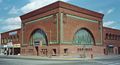
National Farmers Bank in Owatonna by Louis Sullivan.
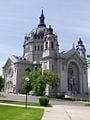
The French Renaissance-style Cathedral of St. Paul in the city of St. Paul.

The Mayo Clinic in Rochester.
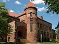
The Richardsonian Romanesque Pillsbury Hall is the second-oldest building on the University of Minnesota-Minneapolis campus.

Fishing in Lake Calhoun in Minneapolis.


Notes
- ↑ 1.0 1.1 Quick Facts: Minnesota United States Census Bureau. Retrieved March 19, 2021.
- ↑ Median Annual Household Income KFF. Retrieved March 19, 2021.
- ↑ 3.0 3.1 Elevations and Distances in the United States United States Geological Survey. Retrieved March 19, 2021.
- ↑ 4.0 4.1 Elevation adjusted to North American Vertical Datum of 1988.
- ↑ Land and Water Area of States Infoplease, February 11, 2017. Retrieved March 19, 2021.
- ↑ Anne Jefferson, The Driftless Area: Fewer glaciers but more topography than the rest of Minnesota Highly Allochthonous, November 30, 2010. Retrieved March 19, 2021.
- ↑ Mark A. Gonzalez, Continental Divides in North Dakota and North America, North Dakota Geological Survey Newsletter 30(1) (Summer 2003). Retrieved March 19, 2021.
- ↑ Mark W. Seeley, Minnesota Weather Almanac (St. Paul: Minnesota Historical Society Press, 2006, ISBN 0873515544).
- ↑ Monthly weather forecast and climate Minnesota, USA Weather Atlas. Retrieved March 19, 2021.
- ↑ David B. Danbom, “Flour Power: The Significance of Flour Milling at the Falls,” Minnesota History 58 (Spring-Summer 2003): 270–285.
- ↑ Minnesota State Symbols Minnesota Legislative Reference Library. Retrieved March 19, 2021.
- ↑ Common Loon All About Birds. Retrieved March 19, 2021.
- ↑ Erik Tormoen, Fake News: The Twin Cities Theater Scene's Claim to Fame Minnesota Monthly, November 22, 2017. Retrieved March 19, 2021.
- ↑ About Minnesota Fringe Minnesota Fringe. Retrieved March 19, 2021.
- ↑ Minnesota Partnership for Biotechnology and Medical Genomics Mayo Foundation for Medical Education and Regents of the University of Minnesota. Retrieved March 19, 2021.
- ↑ Best Colleges in Minnesota U.S. News & World Report. Retrieved March 19, 2021.
ReferencesISBN links support NWE through referral fees
- Breining, Greg, and Paul Chesley. Minnesota. New York: Compass American Guides, 2006. ISBN 1400014840
- Gilman, Rhoda R. The Story of Minnesota's Past. St. Paul: Minnesota Historical Society Press, 1991. ISBN 9780873512671
- Hasday, Judy L. Minnesota (From Sea to Shining Sea). New York: Children's Press, 2003. ISBN 9780516224787
- Heinselman, Miron L. The Boundary Waters Wilderness Ecosystem. Minneapolis: University of Minnesota Press, 1996. ISBN 9780816628056
- Hintz, Martin. Minnesota (America the Beautiful). New York: Children's Press, 2000. ISBN 9780516210407
- Lass, William E. Minnesota: A History. New York: W.W. Norton & Co., 1998. ISBN 9780393046281
- Mech, L. David. The Wolves of Minnesota: Howl in the Heartland. Stillwater, MN: Voyageur Press, 2000. ISBN and ISBN 9780896584648
- Radzilowski, John. Minnesota (On-the-road Histories). New York: Interlink Books, 2006. ISBN 9781566565677
- Seeley, Mark W. Minnesota Weather Almanac. St. Paul: Minnesota Historical Society Press, 2006. ISBN 0873515544
External links
All links retrieved November 9, 2022.
- Constitution of the State of Minnesota.
- Minnesota State Demographic Center
- Perry-Castañeda Library Minnesota Map Collection.
| Political divisions of the United States | |||||||
|---|---|---|---|---|---|---|---|
| |||||||
Credits
New World Encyclopedia writers and editors rewrote and completed the Wikipedia article in accordance with New World Encyclopedia standards. This article abides by terms of the Creative Commons CC-by-sa 3.0 License (CC-by-sa), which may be used and disseminated with proper attribution. Credit is due under the terms of this license that can reference both the New World Encyclopedia contributors and the selfless volunteer contributors of the Wikimedia Foundation. To cite this article click here for a list of acceptable citing formats.The history of earlier contributions by wikipedians is accessible to researchers here:
The history of this article since it was imported to New World Encyclopedia:
Note: Some restrictions may apply to use of individual images which are separately licensed.