File: DominicanRepublicSubdivisions.png
From New World Encyclopedia
No higher resolution available.
DominicanRepublicSubdivisions.png (400 × 276 pixels, file size: 43 KB, MIME type: image/png)
|
|
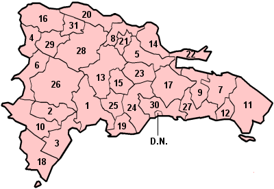
* The national capital, also known as Distrito Nacional (D.N.), is the city of Santo Domingo de Guzmán.
File history
Click on a date/time to view the file as it appeared at that time.
| Date/Time | Thumbnail | Dimensions | User | Comment | |
|---|---|---|---|---|---|
| current | 22:33, 26 June 2007 | | 400 × 276 (43 KB) | Robert Irwin (talk | contribs) | [http://en.wikipedia.org/wiki/Image:DominicanRepublicSubdivisions.png source and rights] |
You cannot overwrite this file.
File usage
The following page uses this file: